


EPA issues final PFAS regulations - April 2024
The United States Environmental Protection Agency (EPA) issued the final PFAS regulations on April 10, 2024. The regulations were initally issued in draft form during 2023.
EPA Regulations
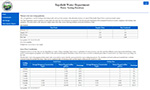
The new EPA regulations set Maximum Contaminant Levels (MCLs) for PFOA (perfluorooctanoic acid) and PFOS (perfluorooctane sulfonic acid) at 4 parts per trillion (ppt); PFNA (perfluorononanoic acid), PFHxS (perfluorohexanesulfonic acid), and GenX (hexafluoroproplene oxide) at 10 ppt; and a hazard index for mixtures of PFNA, PFHxS, GenX and PFBS.
The new regulations are being phased into effect. Systems are required to start testing for these compounds within 3 years, report the results in the annual Water Quality Report, and notify customers of any violations. Systems have 5 years to comply with the new MCLs by either installing appropriate treatment or finding alternative PFAS-free water supplies.
The regulations also created Maximum Contaminant Level Goals (MCLGs) for PFOS and PFOA of 0 ppt. This means that EPA would like to eliminate PFOS and PFOA from water supplies accross the country but current testing protocols, treatment methods, and economic conditions make it infeasible. We expect the MCLs to drop as testing and treatment methods improve.